国际民航组织(ICAO)作为联合国的专门机构,主要因应AF447和MH370航班失踪事件而建立了全球航空遇险和安全系统(GADSS)。GADSS包含的标准和建议措施(SARP)规定了航空公司和飞机运营商在正常情况下以及飞机遇险时的飞机跟踪要求。
GADSS起源和推进情况自2014年3月8日马航MH370航班发生失联事件后,国际民航组织(ICAO)充分吸取事件本身所暴露出的安全隐患,即看似配置了多种类型高技术含量地空监视手段的现代大型飞机,实际上缺乏一种自动、自主、不受第三方影响的的地空实时险情报告手段,导致飞机遇险时地面不容易得到实时准确的情况报告。此外,当前地面对飞机的监控主要依靠雷达,但雷达覆盖范围一般为从海岸向外延伸350公里左右。这意味着,当飞机在跨海飞行或者在偏远地区飞行时,由于信号覆盖不到而无法被地面控制中心掌控精确位置和实际运行状态。一旦发生意外情况,定位和搜救将十分困难
马来西亚航空公司MH370客机失联事件促使人们开始关注如何全程追踪一架飞机,我们该如何保障一架飞机"看得见,听得到,管得住"。为此,近年来,世界航空界大力开展自主的全球范围内航空器监控工作,从而启动了全球飞机遇险跟踪系统(GADSS)的相关工作。
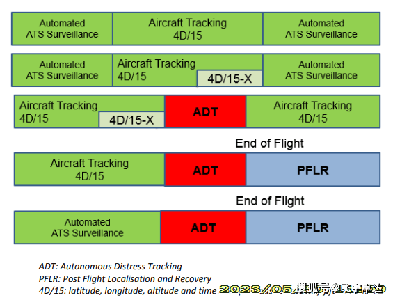
GADSS系统的基本理念是通过发送遇险信号来应对诸如通信系统被非法侵入的挑战,该遇险信号的发送独立于其他机载系统,当飞机飞行高度、速度等出现异常或动力系统失灵等特殊情况时候,该系统基于特定的触发规则就会自动发送信号,从而实现 “危险自动跟踪”(ADT)信号的要求当飞机进入异常状态时,由飞机上独立的系统自动的按照一定的时间间隔,周期性的报告飞机经纬度等必要信息。ICAO 于2016年3月起正式实施这些改进意见,并增加了新的标准和推荐措施(SARP)。
正常的飞机跟踪SARP从2018年11月开始生效,其中规定,航空运营人有责任在其整个运行区域内对其飞机进行跟踪。在无法通过空中交通服务进行跟踪时,运营商应至少每15分钟收到一次飞机位置。与遇险飞机位置有关的SARP将于2021年1月生效,其中要求对遇险飞机进行自动跟踪,并且每分钟应至少更新一次位置。
2017 年 7 月,中国民用航空局发布了《中国民航航空器追踪监控体系建设实施路线图》。
飞机通信寻址与报告系统(ACARS)可以在航空器和地面用户之间通过甚高频、高频或卫星数据链传输报文,实时掌握飞机的空中情况。相比ACARS技术,广播式自动相关监视(ADS-B)具有更强的实时数据传输能力。随着航天技术的成熟与商业小卫星的成本降低,采用星基手段开展空管应用逐渐具备了可行性。未来,星基ADS-B卫星系统将有效解决陆基地面站覆盖能力不足的问题,成为空管系统的重要组成部分。
GADSS的关键组成部分如下图:
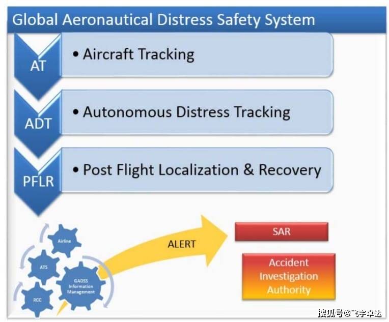
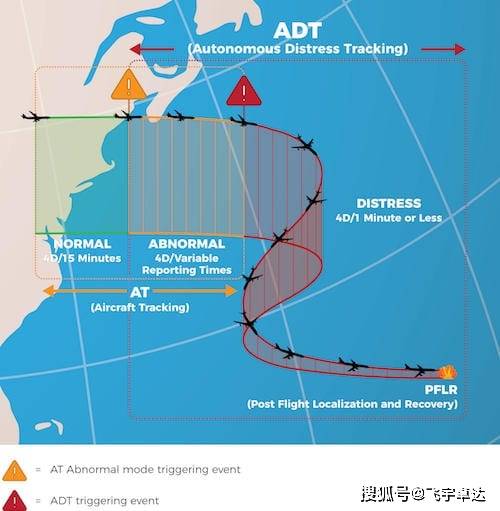
AT:正常运行期间的飞机跟踪——飞机位置信息需要至少每15分钟更新一次,并可用于空中交通服务(ATS)。
ADT:非正常操作期间的自主遇险跟踪(ADT)-当飞机处于遇险状态时,飞机位置信息将至少每分钟传输一次,无需机组人员采取行动。
PFLR:飞行后的定位和数据恢复-向SAR服务提供准确的飞机位置信息(1海里精度或更好)。
Concept
According to the ICAO Concept of Operations, the Global Aeronautical Distress and Safety System (GADSS) will address all phases of flight under all circumstances including distress. This GADSS will maintain an up‐to‐date record of the aircraft progress and, in case of a crash, forced landing or ditching, the location of survivors, the aircraft and recoverable flight data.
The three main functions of the GDASS are:
Aircraft Tracking
The GDASS Aircraft Tracking function is planned to provide an automated 4 dimensional position (latitude, longitude, altitude and time) at a reporting interval of 15 minutes or less. This reporting interval will result in a reduction of the time necessary to resolve the status of an aircraft or, when necessary, help to locate an aircraft. If air traffic services obtain an aircraft position at 15 minute intervals or less, it will not be necessary for the operator to track the aircraft. However, should the aircraft be operating within an area where ATS obtains the aircraft position at intervals greater than 15 minutes, the operator will be required to ensure that the aircraft is tracked.
In general terms the aircraft tracking function:
Autonomous Distress Tracking
The Autonomous Distress Tracking (ADT) function will be used to identify the location of an aircraft in distress with the aim of establishing the location of an accident site within a 6 NM radius. An aircraft is considered to be in a distress condition when it is in a state that, if the aircraft event is left uncorrected, may result in an accident. Triggering criteria might include items such as unusual attitudes, altitudes or speeds, potential collision with terrain, total loss of thrust on all engines, Mode A squawk codes, and others as defined by the operator.
The ADT function will use on-board systems to broadcast either aircraft position (latitude and longitude), or a distinctive distress signal from which the aircraft position and time can be derived. Once the ADT has been triggered by a distress condition event, the aircraft position information will be transmitted at least once every minute.
Post Flight Localization and Recovery
In the event of an accident, the immediate priority is the rescue of any survivors. The ADT function will greatly reduce the potential search area and even more accurate aircraft position information will be provided through the Post Flight Localization function by means of Emergency Locator Transmitter (ELT) and/or homing signals to guide SAR services on site.
To facilitate the ability to locate the wreckage and recover the flight recorder data after an accident, the post flight localization and recovery function specifies a number of requirements for ELTs, Underwater Locator Beacon (ULB) and flight recorders which are being incorporated into the provisions of ICAO